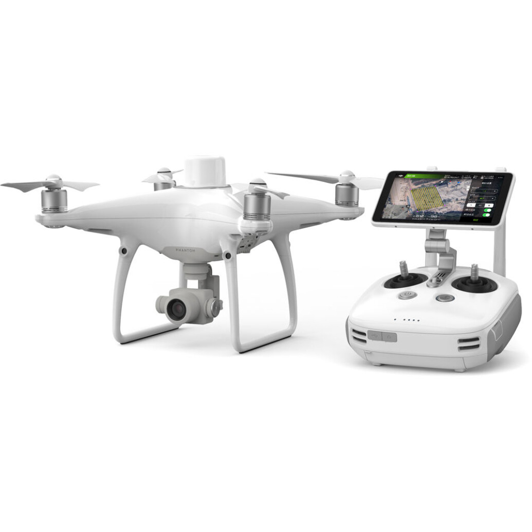
DJI Phantom 4 RTK + D-RTK 2 GNSS Mobile Station Combo with Shield Basic

- Ultra-high-resolution 4K camera
- Camera lenses calibrated for radial and tangential lens distortions
- 1-inch, 20MP CMOS sensor
- 4.3-mile range
- Adjustments for overlap rate, altitude, speed and camera parameters
- GPS accuracy, plus GNSS redundant sensor for poor-signal areas
- Mechanical shutter to eliminate rolling distortion
- Dual planning modes
- Direct loading of KML area files for in-office flight planning
- Strong-wind alarm
- Consistent exposure across all photos
OVERVIEW
Aerial surveying and mapmaking with the Phantom 4 RTK simplify your workflow by requiring fewer ground control points, saving time. The Phantom 4 RTK delivers centimeter-accurate positioning data that produces maps built on improved absolute accuracy—without higher costs.
Precisely Accurate Positioning Modules
DJI integrated a new RTK module into the Phantom 4 RTK for centimeter-level positioning data. The result is improved absolute accuracy on metadata. A redundant GNSS module sits just below the RTK receiver, so even in areas where signals are notoriously weak, such as urban canyons of concrete and steel, flight stability is maintained.
The GS RTK program augments flight planning for both mapping and inspection runs. The pilot can adjust settings, including overlap rate, altitude, speed, and camera parameters. The Phantom 4 RTK will be set up precisely for the work you’re performing on your jobsite.
Continual Alignment Through TimeSync
TimeSync, which is built into the operating system, contributes to improved accuracy by continually aligning the flight controller, camera and RTK module. Using the most accurate metadata, TimeSync fixes positioning data to the center of the 1-inch, 20MP CMOS sensor. The image employs optimization of photogrammetric methods to achieve centimeter-level positioning.
Mobile Workstation
The inclusion in the combo of the D-RTK Mobile Work Station allows connection anywhere, in any workflow, and it provides information—including high wind alerts—that increases accuracy. The work station supplies the Phantom 4 RTK with real-time differential data. By connecting through a 4G dongle or WiFi hotspot, the work station facilitates continuous data flow using the NTRIP protocol, which provides security for data while aiding distribution to multiple users. Data gets to internal or external clients quickly and accurately.
Long Range
The Phantom 4 RTK has a range of 4.3 miles. OcuSync transmits live images in 720p over that entire range. More importantly, 4K video and 20MP still imagery are transmitted for recording over that entire range, sending data that is highly accurate. Stored data can be accessed for detailed analysis and decision-making by stakeholders. The Phantom 4 RTK’s long range greatly augments the aircraft’s wide-area mapmaking and inspection capabilities.
Next Generation Mapping
DJI has rethought its drone technology from the ground-up, revolutionizing its systems to achieve a new standard for drone accuracy – offering Phantom 4 RTK customers centimeter-accurate data while requiring fewer ground control points.
Centimeter level positioning system
A new RTK module is integrated directly into the Phantom 4 RTK, providing realtime, centimeter-level positioning data for improved absolute accuracy on image metadata. Sitting just beneath the RTK receiver is a redundant GNSS module, installed to maintain flight stability in signal-poor regions such as dense cities. Combining both modules, the Phantom 4 RTK is able to optimize flight safety while ensuring the most precise data is captured for complex surveying, mapping and inspection workflows.
Fit the Phantom 4 RTK to any workflow, with the ability to connect this positioning system to the D-RTK 2 Mobile Station, NTRIP (Network Transport of RTCM via Internet Protocol) using a 4G dongle or WiFi hotspot, or store the satellite observation data to be used for Post Processed Kinematics (PPK).
Gather Accurate Data with TimeSync
To take full advantage of the Phantom 4 RTK’s positioning modules, the new TimeSync system was created to continually align the flight controller, camera and RTK module. Additionally, TimeSync ensures each photo uses the most accurate metadata and fixes the positioning data to the center of the CMOS – optimizing the results from photogrammetric methods and letting the image achieve centimeter-level positioning data.
Precise Imaging System
Capture the best image data with a 1-inch, 20 megapixel CMOS sensor. Mechanical shutter makes mapping missions or regular data capture seamless as the Phantom 4 RTK can move while taking pictures without the risk of rolling shutter blur. Due to the high resolution, the Phantom 4 RTK can achieve a Ground Sample Distance (GSD) of 2.74 cm at 100 meters flight altitude. To ensure each Phantom 4 RTK offers unparalleled accuracy, every single camera lens goes through a rigorous calibration process where radial and tangential lens distortions are measured. The distortion parameters gathered are saved into each image’s metadata, letting post-processing software adjust uniquely for every user.
Purpose-Built Flight Planning Application
A new GS RTK app allows pilots to intelligently control their Phantom 4 RTK, with two planning modes – Photogrammetry and Waypoint Flight – alongside a more traditional flight mode. The planning modes let pilots select the drone’s flight path while adjusting overlap rate, altitude, speed, camera parameters and more, offering an automated mapping or inspection workflow.
The GS RTK app has been built with its users in mind and therefore has a range of features built for specific mapping or inspection workflows. The app has implemented direct loading of KML area files for in-office flight planning, a new shutter priori mode to keep exposure consistent across all photos and a strong wind alarm to warn pilots of adverse conditions.
Mobile SDK Supported
The Phantom 4 RTK is compatible with the DJI Mobile SDK, opening up its functions to automation and customization through a mobile device (coming soon).
OcuSync Transmission System
Enjoy stable and reliable HD image and video transmission at distances of up to 7 km, great for mapping larger sites. Unobstructed, free of interference, when FCC compliant. Maximum flight range specification is a proxy for radio link strength and resilience. Always fly your drone within visual line of sight unless otherwise permitted.
Seamless Compatibility with D-RTK 2 Mobile Station
Support your Phantom 4 RTK missions with the D-RTK 2 Mobile Station – providing real-time differential data to the drone and forming an accurate surveying solution. The Mobile Station’s rugged design and OcuSync 2transmission system ensures you can gain centimeter-level accurate data with your Phantom 4 RTK in any condition.
Start Mapping Today
With a built-in flight planning app (GS RTK) and an easy method to collect RTK data (RTK Network or D-RTK 2 Mobile Station), pilots have a full solution for any surveying, mapping or inspection workflow – right out of the box.
In the Box
- DJI Phantom 4 RTK
- Remote Controller
- Propeller Pair x 4
- Intelligent Flight Battery x 2
- Ac Power Cable
- Remote Controller Intelligent Battery
- Ac powe Adapter
- Intelligent Battery Charging Hub
- Intelligent Flight Battery Charging Hub
- Gimbal Clamp
- MicroSD Card (16GB)
- Carrying Case
- Micro USB Cable
- USB-C Cable
- USB-C OTG Cable
Brand
camera attributes
| Image Sensor Size | 1" CMOS; Effective pixels: 20 M |
| Recording File Format (Image) | JPEG |
| Recording File Format (Video) | MOV |
lens specification
| Maximum Aperture | f/2.8 - f/11 |
brand
| Brand | DJI |
drone specifications
| Storage | MicroSD, Max Capacity: 128 GB. Class 10 or UHS-1 rating required Write speed=15 MB/s |
| Drone Type | Enterprise |
| Flight Duration | Approx. 30 minutes |
| Maximum Ascent Speed | 6 m/s (automatic flight); 5 m/s (manual control) |
| Vision System | Velocity Range: =31 mph(50 kph) at 6.6 ft(2 m) above ground with adequate lighting<br> Altitude Range: 0-33 ft(0 - 10 m)<br> Operating Range: 0-33 ft(0 - 10 m)<br> Obstacle Sensing Range: 2-98 ft(0.7-30 m)<br> FOV: Forward/Rear: 60°(horizontal), ±27° (vertical)<br> Downward: 70° (front and rear), 50° (left and right)<br> Measuring Frequency: Forward/Rear:10 Hz;<br> Downward: 20 Hz<br> |
| Number of Axes (Gimbal) | 3-axis (tilt, roll, yaw) |
| Control Range (Gimbal) | Pitch: -90° to +30° |
| Angular Speed (Gimbal) | 90°/s |
| Battery Capacity | <b>Intelligent Flight Battery: </b>5870 mAh |
| Weight | <b>Drone</b><br> Takeoff 1391 g<br> <b>Intelligent Flight Battery</b><br> Net Weight: 468 g<br> |
| Lens | FOV 84°;8.8 mm / 24 mm(35 mm format equivalent:24 mm);<br> f/2.8 - f/11, auto focus at 1 m - 8 |