The ability to travel back in time and see how some famous locations appeared years ago is a pretty cool concept. All you need to do to view these antiquated images is select the “view historical imagery” option from the precise location, whenever you see the clock symbol on the Google Earth map. Clicking this symbol will present you with the option of utilizing a sliding tool to observe the location's past and present images through time.
With this highly innovative concept at our disposal, we were able to skim through myriad sites on Google Earth and came back with some startling results of how they looked years ago as opposed to their current states.
Dubai, UAE

The radical development of the Emirates' premiere city Dubai isn't evident solely from its skyrise apartments, but also right through its entire shore area. Although, the most famous maps on Dubai are of its manmade islands and two lavish palm tree resorts, Google Earth's historical imagery throws up some stunning revelations which show how much the city's coastline has progresses over the past 10 years.
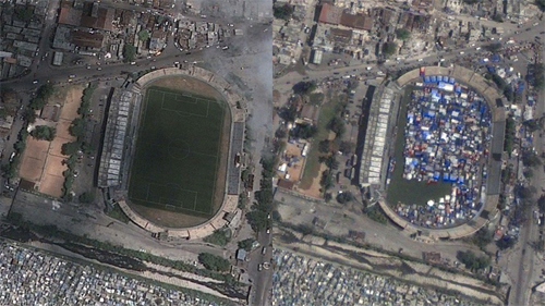
Port-au-Prince, Haiti

The two contrasting images clearly show the effects of the Jan 12, 2010 earthquake and the subsequent rehabilitation efforts for those who were left homeless in the aftermath of this terrible natural disaster. As per official statistics, around 250,000 homes were decimated and several of homeless took haven in the city's soccer stadium, which was soon littered with temporary abodes mere weeks after the earthquake.
Minamisanriku, Japan

The town of Minamisanriku in Japan used to be one of the country's most vibrant coastal towns bustling with energy and civilization, until disaster struck in the form of the terrible Japan earthquake on Mar 11, 2011. Sprawling docks sank into the ocean, sturdy buildings were razed to the ground, and the town's famous sports complex on the sea itself was completely gobbled up by the waves.
Las Vegas, Nevada

Google Earth's unbelievable realism and accuracy is easily gauged by these images of past and present Las Vegas. While the before pictures take us back to the 1950s when Las Vegas was nothing but a barren desert, the images from 2013 show us how the city became the hub of entertainment and commercialism over the years.
Waco, Texas

The famous West Fertilizer Company's factory in north Waco, Texas, experienced a major explosion on Apr 17, 2013, which totally leveled its structure. The before and after images of the factory are precisely captured by Google Earth.
The above examples vividly display the potency of the Google Earth software and the efficiency with which its maps capture realistic events across diverse timelines. Google Earth's historical imagery function is unquestionably a huge boon for people who would like to stay in touch with their doses of history while visiting certain locations or on their travels.
via Mashable
Photo credits - Google Earth Blog